

Unlock the Power of Drone Imaging for Public Works and City Departments
- camron246
- Jan 22, 2025
- 2 min read
Updated: Jan 26, 2025


At CADI Services LLC, we specialize in providing advanced drone imaging solutions tailored for public works and city departments. Utilizing cutting-edge technology, including the DJI Mavic 3T, Mini 4 Pro, DJI Terra, and Pix4Dmatic, we bring unparalleled precision, efficiency, and cost-effectiveness to surveying and inspection projects.
Transforming Public Works with Drone Surveying
Traditional methods of surveying can be time-consuming, labor-intensive, and costly. With drone technology, we redefine these processes, delivering highly accurate and actionable data in a fraction of the time. Our drones are equipped with high-resolution imaging capabilities, thermal sensors, and advanced mapping software to create detailed topographic maps, 3D models, and orthomosaics.
Whether it’s infrastructure planning, land development, or monitoring environmental changes, drone surveying offers:
Accuracy: Capturing centimeter-level precision for data you can trust.
Efficiency: Covering large areas quickly, reducing project timelines.
Safety: Minimizing risks by keeping personnel out of hazardous environments.
Streamlining Inspections for City Departments
City departments tasked with maintaining infrastructure face constant challenges. Our drone inspection services simplify the process, offering fast, safe, and detailed evaluations of critical assets like bridges, roads, water systems, and power lines.
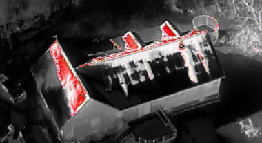
Using the DJI Mavic 3T’s thermal imaging capabilities, we can detect issues such as heat leaks, structural damage, or failing electrical systems before they escalate. The Mini 4 Pro’s compact size and high-quality camera make it ideal for capturing hard-to-reach areas without the need for scaffolding or heavy machinery.
Our drone inspections provide:
Cost Savings: Reducing the need for expensive equipment and manual labor.
Comprehensive Reporting: Generating detailed visual and thermal data for decision-making.
Accessibility: Reaching confined or elevated spaces with ease.
Our Tools and Expertise
DJI Terra & Pix4Dmatic Software: These industry-leading platforms allow us to process drone data into actionable insights. From creating detailed 3D models to performing volumetric calculations, we deliver precise results tailored to your needs.
Real-Time Results: With our advanced equipment and software, we can often provide preliminary findings on-site, enabling quicker responses to urgent issues.
Why Choose CADI Services?
At CADI Services, we are more than drone operators—we are partners in your success. We understand the unique challenges faced by public works and city departments and tailor our services to meet your goals. By choosing us, you gain access to:
Experienced professionals committed to delivering high-quality results.
Customized solutions that align with your budget and timeline.
A focus on sustainability, safety, and innovation.
Let’s Elevate Your Projects
With drone imaging, public works and city departments can achieve new levels of precision, efficiency, and safety in their operations. At CADI Services, we are ready to help you harness this technology to drive better outcomes for your community.
Contact us today at [your contact information] to learn more about our drone surveying and inspection services. Let’s discuss how we can transform your next project with the power of drone technology!


Comments